Bureau of Reclamation daily operations data shows Lake Mohave holding at 643 ft elevation through mid-June 2026, with Davis Dam releasing approximately 13,000 to 15,000 cubic feet per second on most days. Full pool elevation is 647 ft.
Colorado River · U.S. Bureau of Reclamation
Lake Mohave
Davis Dam · 1.81 MAF capacity at full pool
Loading live data
Loading map…
About Mohave
Lake Mohave sits between Lake Mead and Lake Havasu on the lower Colorado River, in the Black Canyon section along the Arizona–Nevada border. It is a re-regulating reservoir downstream of Hoover Dam.
Davis Dam was completed in 1953 and is operated by the U.S. Bureau of Reclamation. Its primary function is to smooth Hoover Dam's hourly hydropower releases into a steadier flow before water enters Lake Havasu.
Daily storage, elevation, and release values come from the USBR Reclamation Information Sharing Environment (RISE). Lake Mohave does not have federally codified shortage tiers, so AZMap presents a percent-of-capacity readout without a tier classification.
Recent coverage
Coverage from federal agencies and named news outlets. AZMap is not the publisher.
- Lower Colorado River Daily Report: Reservoir Elevations and Contents for June 2026
- Davis Dam & Parker Dam Projected Water Release Schedules
Bureau of Reclamation published its updated Davis Dam release schedule on June 21, 2026, with generating units operating across a range of approximately 1,400 to 4,600 cubic feet per second. Boaters are advised that releases are estimates subject to change at any time.
- Lower Colorado River Operations | Lower Colorado Region | Bureau of Reclamation
Bureau of Reclamation's Lower Colorado operations hub was updated June 17, 2026, and now lists two new 2026 technical studies: the Lake Mohave and Lake Havasu Area-Capacity Survey Sensitivity Study, and updated Reservoir Capacity Allocations, both replacing prior 2022 baselines.
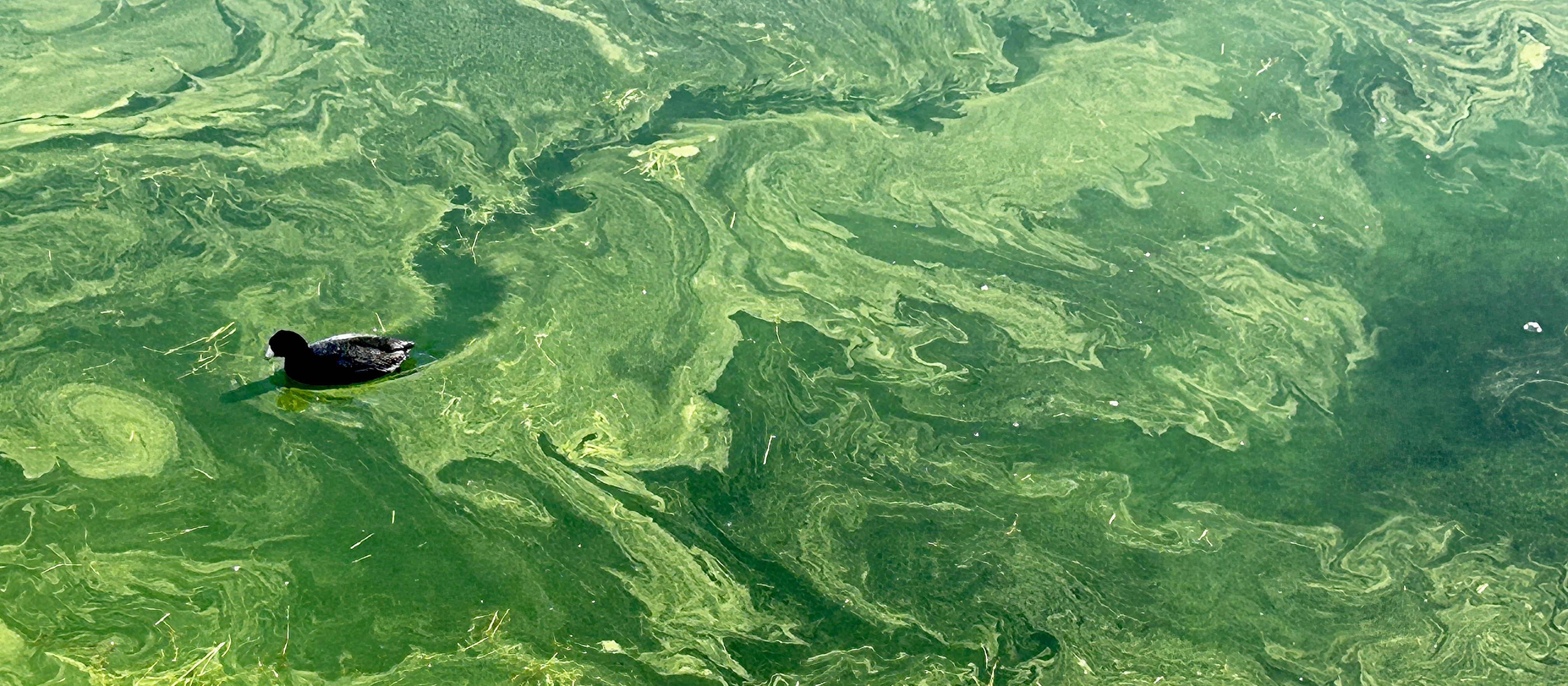
- Park Service warns of harmful algae found in Lake Mohave
The National Park Service confirmed a Harmful Algal Bloom (HAB) in water samples from Nelson's Landing and Cottonwood Cove on Lake Mohave. Visitors are urged to limit body contact with affected water; toxins can cause nausea, seizures, or serious illness in pets.
- Harmful Blue-Green Algae Blooms (HABs) - Lake Mead National Recreation Area
NPS maintains an active HAB advisory page for Lake Mead National Recreation Area, which includes Lake Mohave. Microcystis, a blue-green bacteria that concentrates in coves under warm and calm conditions, is the species most often responsible for toxic blooms at the site.
- Alerts & Conditions - Lake Mead National Recreation Area
As of May 2026, all three Lake Mohave launch ramps (Cottonwood Cove, Katherine's Landing, Willow Beach) are operable. NPS also issued 2026 seasonal trail closures through September 30 for strenuous canyon routes, with Lake Mohave water access to the hot springs remaining open.
- Arizona Water Factsheet: Mohave County
The University of Arizona WRRC released a water factsheet covering Lakes Mohave, Havasu, and Mead and the water supply challenges facing lower Colorado River communities. The report addresses drought resilience, ongoing shortages, and the role of reservoir recreation in Mohave County.
- Implementation Effects of New Lake Mohave and Lake Havasu Area-Capacity Survey Sensitivity Study
Reclamation published updated area and capacity tables for Lake Mohave using 2021-2022 survey data, replacing figures from 1949. The new data puts available live storage at 1,873,650 acre-feet and surface area at 28,890 acres at full spillway gate elevation (647 ft).